Why Does Savannah Have 22 Historic Squares?
If you have ever walked through Savannah, you have probably noticed something unusual: the city is filled with beautiful public squares shaded by live oaks and surrounded by historic buildings.
But why does Savannah have so many squares—and why are there 22 of them today?
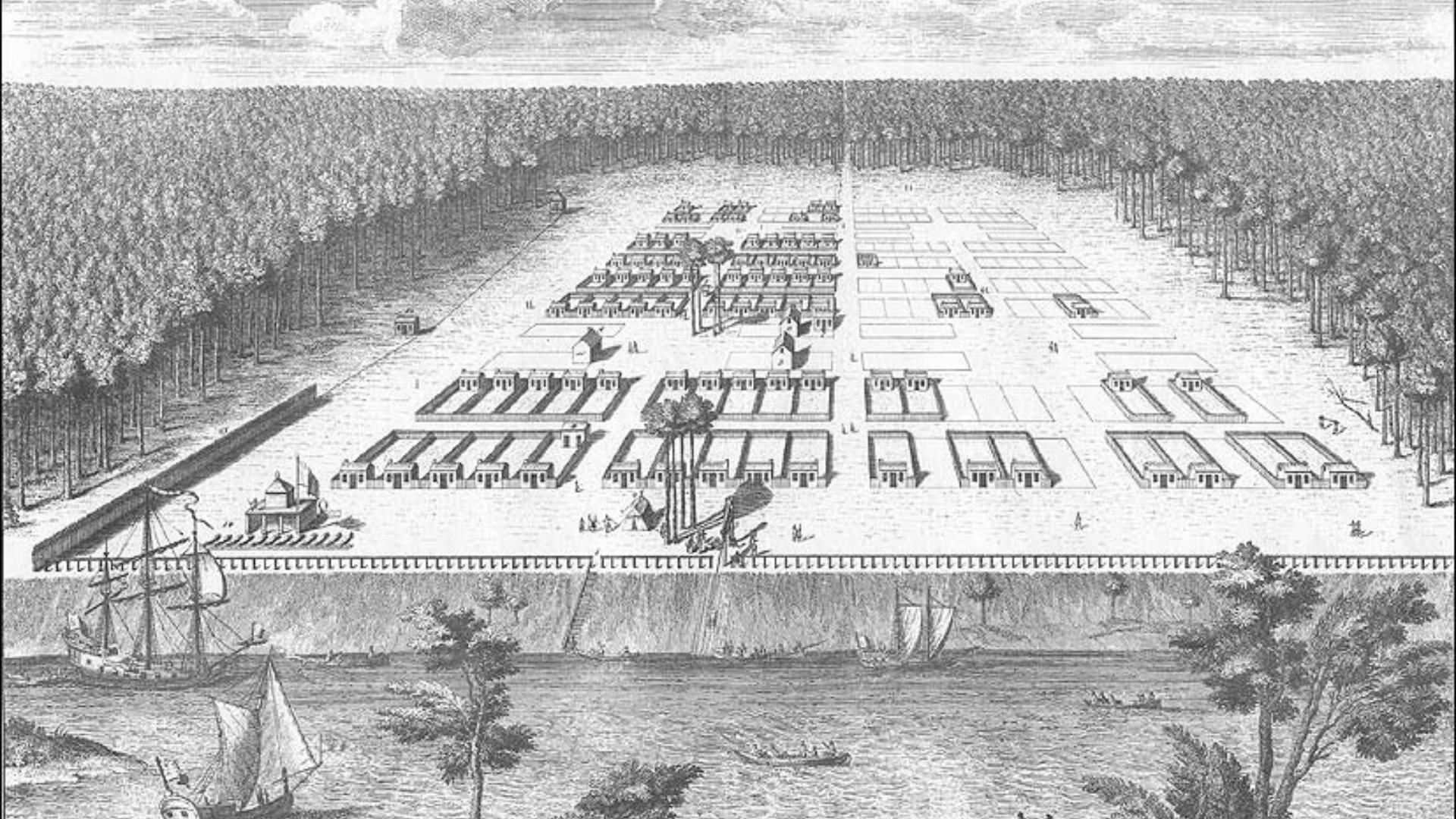
The answer goes back to the city's founding in 1733. Savannah was designed around a distinctive system of wards, streets, residential lots, and public squares. The squares were not simply parks added to the city later. They were fundamental parts of the original plan and helped organize how Savannah grew.
Today, 22 historic squares remain in downtown Savannah, creating one of the city's most recognizable features and an important part of its historic landscape.
Savannah's Squares at a Glance
Savannah was founded: 1733
Original planner: General James Edward Oglethorpe and the early Georgia colonists
Basic planning unit: The ward
Center of each ward: A public square
Historic squares today: 22
Two lost squares: Liberty Square and Elbert Square
Purpose: Civic, social, organizational, and sometimes defensive functions
What makes them special: The squares remain integrated into Savannah's historic street and building pattern
Why Did Savannah Have So Many Squares?
Savannah's squares were part of a larger urban system known as the ward plan.
When Savannah was founded in 1733, the city was organized into wards. Each ward was centered on a public square, with streets and building lots arranged around it.
The square wasn't an afterthought or simply a decorative park. It was one of the basic building blocks of the city.
The plan allowed Savannah to grow by adding additional wards while maintaining a consistent pattern of streets, buildings, and public open spaces.
This is one reason Savannah feels so different from many other American cities. Instead of a simple grid of streets filled almost entirely with buildings, the historic plan repeatedly interrupts the street grid with public squares.
How Did Savannah's Ward System Work?
A Savannah ward was organized around its central square.
Residential lots, known as tything lots, were arranged around the ward, while trust lots were set aside for public and institutional buildings.
The streets surrounding the ward provided connections through the city, while the square created an open public space at its center.
This system served practical purposes as well as social ones. The squares provided places for residents to gather and were incorporated into the organization of civic and military life in the early settlement.
The result was a city designed around neighborhoods with a recognizable center rather than one continuous expanse of streets and buildings.
Were All 22 Squares Created in 1733?
No.
This is an important part of Savannah's history.
The first wards and squares were laid out when the city was founded, but Savannah's plan was designed to expand over time. As the city grew, additional wards and squares were added.
The plan continued to be extended southward and westward during the 18th and 19th centuries.
By the 19th century, Savannah's system included 24 squares. Two—Liberty Square and Elbert Square—were later lost or substantially disrupted by changes to the city's transportation infrastructure.
Today, 22 historic squares remain.
So the 22 squares visitors see today are not all remnants of the original six wards established in 1733. They represent more than a century of Savannah's planned growth.
What Are Savannah's 22 Historic Squares?
The 22 surviving historic squares are:
Chatham Square
Chippewa Square
Columbia Square
Crawford Square
Ellis Square
Franklin Square
Greene Square
Johnson Square
Lafayette Square
Madison Square
Monterey Square
Oglethorpe Square
Orleans Square
Pulaski Square
Reynolds Square
Taylor Square
Telfair Square
Troup Square
Washington Square
Warren Square
Whitefield Square
Wright Square
Each has its own history, architecture, monuments, landscaping, and surrounding buildings.
And because the squares were created at different points in Savannah's development, walking from one to another can reveal how the city changed over time.
Why Are Two Squares Missing?
Savannah once had two additional squares that no longer survive as complete historic squares: Liberty Square and Elbert Square.
Both were affected by 20th-century transportation changes.
In the 1930s, U.S. Highway 17 was routed through downtown Savannah, cutting through Franklin, Liberty, and Elbert Squares. Franklin Square was eventually restored, but Liberty and Elbert were not.
Today, Liberty Square and Elbert Square are considered Savannah's two lost squares. Portions of their historic landscapes remain, but neither survives as a complete square in the way the other 22 do.
Their history is an important reminder that Savannah's historic landscape was not preserved unchanged. The city continued to develop, and transportation, urban renewal, and other changes altered parts of the original plan.
What Is the Most Famous Square in Savannah?
There isn't one official "most famous" square, but several are especially well known to visitors.
Chippewa Square is perhaps one of the most recognizable because of its central location on Bull Street and its appearance in the movie Forrest Gump. The square was laid out in 1815 and commemorates the American victory at the Battle of Chippewa during the War of 1812.
Johnson Square is Savannah's oldest square and was part of the city's original 1733 plan. It is named for Robert Johnson, the colonial governor of South Carolina who supported the establishment of the Georgia colony.
Wright Square is another of the original squares and has important connections to Native American history, colonial Georgia, and the city's early development.
Reynolds Square, Telfair Square, and Oglethorpe Square are also among the earliest squares in Savannah.
Farther south, squares such as Monterey, Lafayette, Madison, Troup, and Taylor reflect the city's later 19th-century expansion.
Why Are Savannah's Squares So Green?
The squares were designed as open public spaces within the urban plan.
Over the centuries, their landscaping evolved. Today, many are characterized by mature live oaks, lawns, pathways, monuments, benches, and other plantings.
The greenery is more than decoration. The squares function as public outdoor spaces within the city's historic street network, creating places where people can pause, gather, walk, and experience the architecture surrounding them.
The mature trees also contribute to the distinctive character of Savannah's streets and squares.
Did the Squares Always Look the Way They Do Today?
No.
One of the interesting things about Savannah's squares is that they have changed considerably over time.
Their landscaping, pathways, monuments, plantings, and uses have evolved throughout the 19th and 20th centuries.
Some squares have been altered, paved over, divided by roads, or restored. Ellis Square, for example, was once lost beneath a large parking garage and was later reclaimed and restored as a public square.
Franklin Square was also disrupted by transportation changes before being restored.
The fact that the squares have changed while the underlying street pattern remains recognizable is an important part of Savannah's preservation story.
Why Are Savannah's Squares Important to the City's History?
The squares are important because they allow you to see Savannah's history in the physical organization of the city itself.
You don't have to visit a museum to see the original planning concept. You can walk through it.
The relationship between the squares, streets, buildings, churches, homes, and public spaces helps explain how Savannah developed from a small colonial settlement into the city visitors see today.
The squares also provide a way to understand different periods of Savannah's history.
Around one square, you might encounter colonial-era history. Around another, you may see architecture from the antebellum period. Elsewhere, monuments and buildings tell stories about the Revolutionary War, the Civil War, immigration, slavery, religion, education, preservation, and the people who shaped Savannah.
Why Does Savannah Feel So Walkable?
The squares are one reason Savannah's Historic District is so enjoyable to explore on foot.
The original plan created a network of relatively short blocks, interconnected streets, and public squares. The squares interrupt the street grid and provide natural places to stop along the way.
Instead of walking for blocks without interruption, you repeatedly encounter a new public space, monument, historic building, or architectural view.
This makes the squares more than destinations themselves. They help create the rhythm of walking through Savannah.
Can You Visit All 22 Squares?
Yes, but you don't have to see all 22 to appreciate Savannah's historic plan.
The squares are spread throughout the Historic District, and exploring all of them would make for a much longer walk than simply visiting the most famous ones.
For a first visit, you might encounter several of the most prominent squares while exploring the central Historic District, including Johnson, Wright, Chippewa, Madison, Lafayette, Monterey, and Forsyth Park.
If you have more time, exploring additional squares can give you a better understanding of how the city's neighborhoods developed.
One of the most interesting things about visiting multiple squares is noticing how different they can feel even though they share the same basic role in Savannah's urban design.
What Can You Learn by Walking Through Savannah's Squares?
The squares are a useful starting point for understanding much more than Savannah's architecture.
They can help answer questions such as:
Why was Savannah founded where it was?
How did James Oglethorpe's original plan work?
How did Savannah expand beyond its original settlement?
What role did Native Americans play in Savannah's early history?
How did slavery shape the city's development?
Why are Savannah's historic buildings arranged the way they are?
How did the Revolutionary War and Civil War affect the city?
Why were some squares lost?
How did Savannah's preservation movement develop?
Once you understand the basic logic of the squares, the Historic District becomes easier to read.
You begin to see the city not simply as a collection of beautiful buildings, but as a carefully organized historic landscape.
Exploring Savannah's Squares on Foot
One of the easiest ways to understand the relationship between Savannah's squares, streets, and historic buildings is to explore them on foot.
A walking tour can add historical context by explaining how the ward system shaped the city and how individual squares connect to the people, buildings, and events around them.
On the History of Savannah Walking Tour, I take a small group through the Historic District at a relaxed pace, using the city's squares and historic landmarks to explain how Savannah developed from its founding in 1733 onward.
The tour is approximately 90 minutes and about 1.5 miles, beginning at Chippewa Square and ending in Forsyth Park.
Rather than simply pointing out the sights, I focus on the history behind them—the people, decisions, events, architecture, and city planning that shaped Savannah.
A Note From Your Guide, Sarah
I've been sharing Savannah's history with visitors for more than eight years, and one of my favorite things about guiding in the Historic District is showing people how much history is contained in the city's layout.
Once you understand why the squares are there and how the ward system worked, Savannah starts to make more sense.
The buildings, streets, trees, monuments, and public spaces are all connected.
That's what makes exploring Savannah on foot so rewarding: you're not just looking at individual landmarks. You're walking through a historic city plan that is still visible in the city around you.
Final Thoughts: Why Does Savannah Have 22 Squares?
Savannah has 22 historic squares because public squares were a fundamental part of the city's planned development.
Beginning with the original wards established in 1733, Savannah expanded its distinctive system of squares as the city grew. Over time, 24 squares existed within the historic downtown plan, but Liberty and Elbert Squares were lost or substantially disrupted by 20th-century transportation changes.
The 22 squares that remain today are therefore more than beautiful parks.
They are pieces of Savannah's original urban plan—and some of the best places to understand how the city developed over nearly three centuries.
If you want to go beyond simply seeing Savannah's squares and understand the history behind them, a walking tour is a great place to start.
Come explore Savannah's history on foot. Book a Tour